

1838 Survey: 60N 27W in Daviess County, MO
1838 Survey mapping 60N 27W in Daviess County, MO.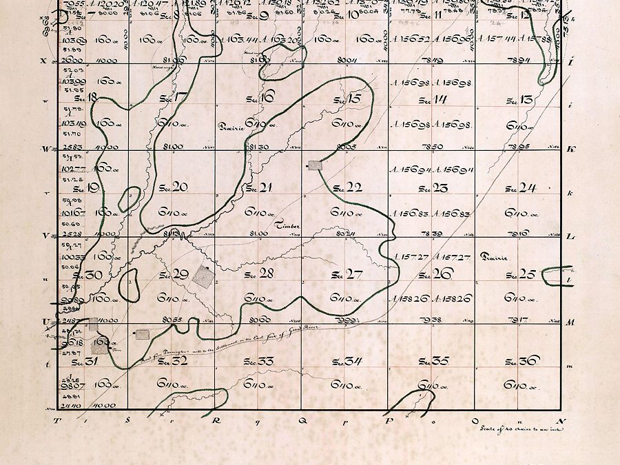
1838 Survey: 60N 26W in Daviess County, MO
1838 Survey mapping 60N 26W in Daviess County, MO.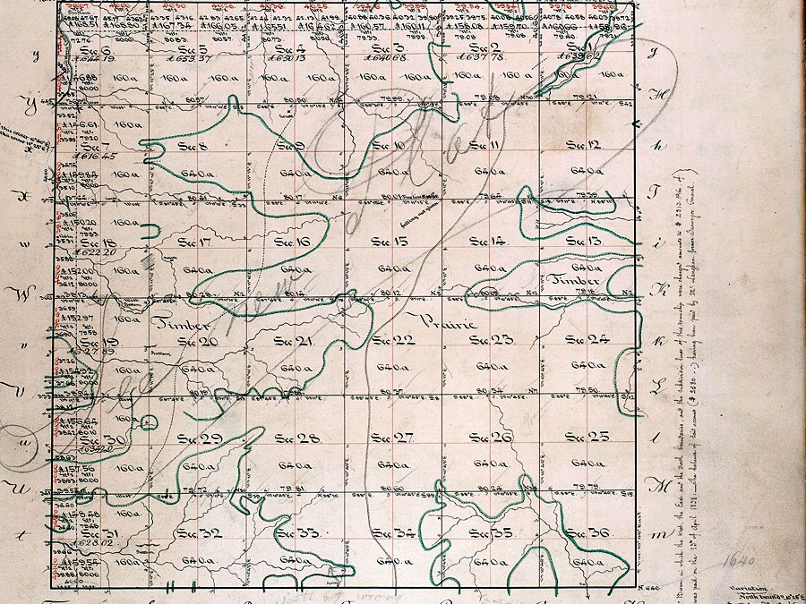
1838 Survey: 59N 29W in Daviess County, MO
1838 Survey mapping 59N 29W in Daviess County, MO.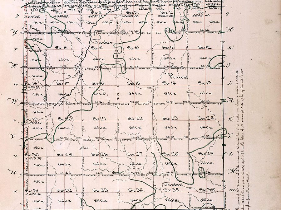
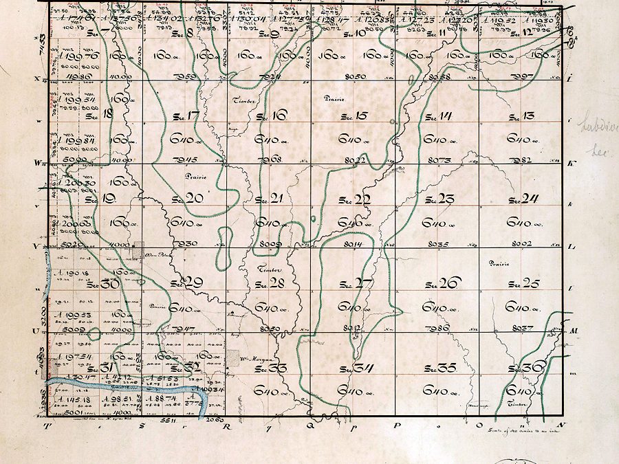
1838 Survey: 59N 28W in Daviess County, MO
1838 Survey mapping 59N 28W in Daviess County, MO.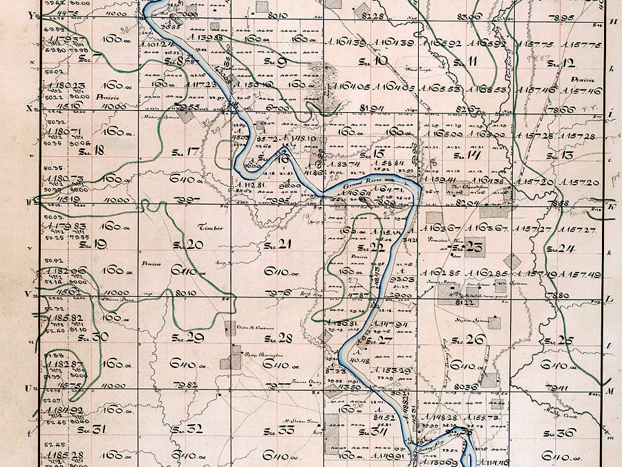
1838 Survey: 59N 27W in Daviess County, MO
1838 Survey mapping 59N 27W in Daviess County, MO.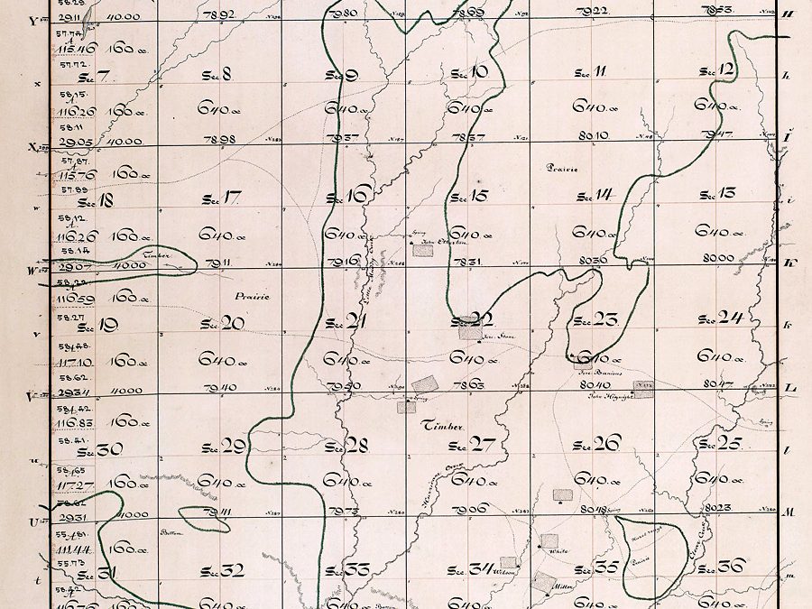
1838 Survey: 59N 26W in Daviess County, MO
1838 Survey mapping 59N 26W in Daviess County, MO.
1838 Survey: 58N 29W in Daviess County, MO
1838 Survey mapping 58N 29W in Daviess County, MO. (older version)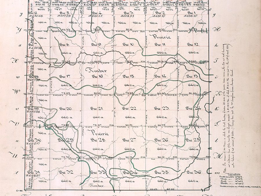
1838 Survey: 58N 28W in Daviess County, MO
1838 Survey mapping 58N 28W in Daviess County, MO.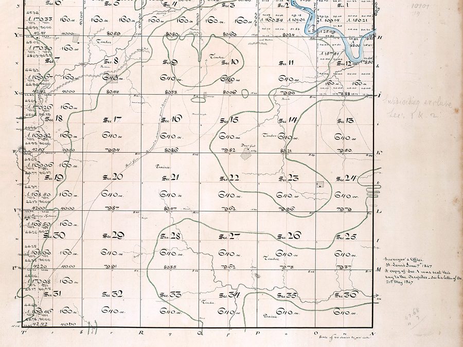
1838 Survey: 58N 27W in Daviess County, MO
1838 Survey mapping 58N 27W in Daviess County, MO.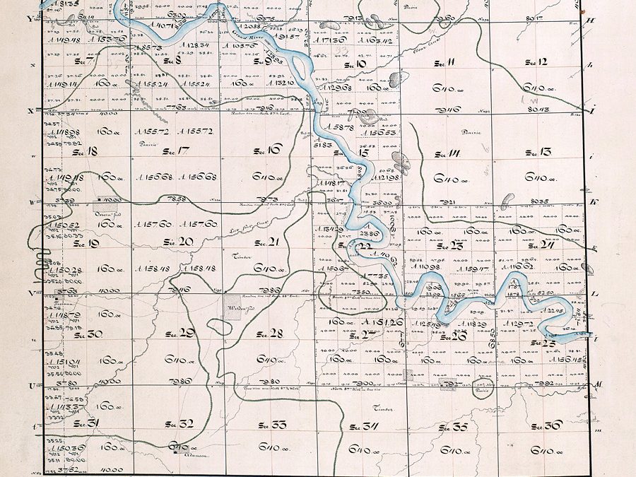
1838 Survey: 58N 26W in Daviess County, MO
1838 Survey mapping 58N 26W in Daviess County, MO.
Pioneers: “Trail of Death” Potawatomi Indian Relocation
Armed conflict between Mormons and Missourians was not the only tragedies recorded in the frontier region of Northwest Missouri during 1838. Today a plaque dedicated on the original campsite in Richmond, MO, is a reminder of the “Trail of Death” march from...
Mormon War: Men that Mustered Out Against the Mormons
The following lists local men thought to have mustered in response to the Governor’s call concerning the Mormon War of 1838 which saw approximately 1,500 state militia confront Mormons located in Caldwell and Daviess counties in 1838. Captain Edward Smith...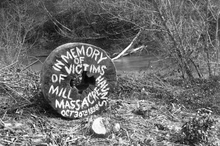
Mormons: Millstone Once Marked Haun’s Mill Location
On Oct. 30, 1838, more than 200 members of the Livingston County Militia rode into Haun’s Mill, a small Mormon settlement approximately 10 miles south of Breckenridge, MO. Many of the women and children were able to escape by fleeing into the nearby woods,...
Mormons: John Doyle Lee an Active Pioneer in Daviess County, MO
The following account offers insight about the beginnings of Daviess County and, in particular, the role one pioneer played. Judge John Doyle Lee eventually was convicted of murder and executed in Utah Territory after the Mountain Meadow massacre. He was known as...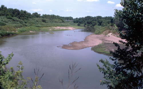
Pioneers: Daviess County’s First Grand River Ferry
Daviess County government was first founded in the spring of 1837, but some settlers had been here for seven years as part of northern Ray County. One of the first businesses in the county was a ferry across Grand River, at the mouth of Honey Creek. I was unable to...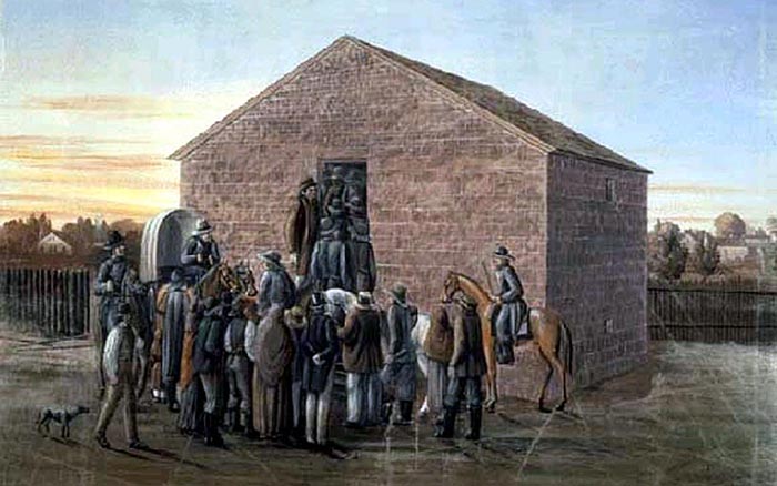
Mormons: 60-acre Log House Site Near Far West, MO
Archaeological investigation conducted in 1996 focuses on Far West in Caldwell County, MO, especially the C.C. Rich Log House and the Rich Settlement area of 1837. In 1996 an archaeological investigation sponsored by Missouri Mormon Frontier Foundation (MMFF), was...
Pioneers: ‘List of Firsts’ as Daviess County Organized 1836
Daviess County, MO, organized on Nov. 29, 1836, when a legislative bill introduced by Rep. Alexander Doniphan was passed by both the Missouri Senate and the Missouri House and signed by Gov. Boggs on Dec. 29th. The county was named after Col. Joseph H. Daviess who...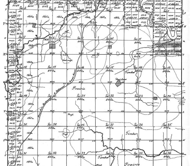
Pioneers: Converting Trails into Daviess County Roads
County judges in the early days of Daviess County spent much time ordering and approving roads in the county. These would be called trails today since they were only 30-foot wide paths or muddy wagon tracks across open ground. At intersections, “finger...
Pioneers: Before Gallatin, There Was Coon Grove in Monroe Township
In a part of Daviess County that became Monroe Township was a place called Coon Grove. It was one of the centers of activity in the area before Gallatin was organized in 1838. Andrew (Bva 1784) and Mary C. Collins McHaney (Bva 1787) came to Coon Grove in 1832, which...
Visit the 1889 Squirrel Cage Jail, located 2 blocks west of the Daviess County Courthouse in Gallatin, MO. This historic relic is listed on the National Register of Historic Places and serves as a visitors’ center — by appointment,
Trudi Burton, ph: 660.663.7342
Search digital posts from 1999 to 2021:
GallatinNorthMissourian.com
Read the last special edition published by the Gallatin North Missourian in 2021:
Daviess County History Guide