
Storms on Thursday night, June 29, 2017, and continued rain on Friday, June 30 saturated the ground in Northwest Missouri. Rivers and streams ran full and with nowhere else to go, the accumulating water collected on fields, drowning crops and closing highways.
This website brought to you in part by the following sponsor:

Find out how to advertise here - Email us! [email protected]

Flooding waters of the Grand River, looking east from Muddy Creek in Daviess County, MO, in 2017.

Grand River looking north from Muddy Creek in Daviess County, MO, in 2017.
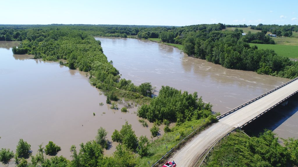
Grand River west of McGill Bridge, flooding the farmland owned by Rick Tolen (house 2nd to right)
Area farmers watched their soybean and corn fields slowly succumb to the rising water.
Larry Vaughn, a farmer at Pattonsburg, drove past Old Pattonsburg and as far south as Hwy. 69 would take him before the highway disappeared under a lake of blue. This was on Friday, June 30, around 10:30 a.m.
Until now, no flood in recent memory has matched the devastating flood of 1993 which prompted the whole town of Pattonsburg to move uphill. But their have been other years when the Grand overflowed its banks. Historic crests for the Grand River are:
-
-
- Aug. 9, 1909 — 40 ft.
- July 24, 1993 — 36.60 ft.
- June 30, 2017 — 35.92 ft. (at Pattonsburg; flood stage is 25 ft.)
- May 8, 2007 — 34.27 ft.
- June 1, 1947 — 34.25 ft.
- Sept. 14, 1973 — 33.80 ft.
-
Mr. Vaughn looked out over the fluid fields, not sure whether this flood matched the one in 2007. “If it’s not the most water, then it doesn’t miss it by much,” he said.

Mr. Vaughn owns 40 acres and rents 160 more. The land lies along the edges of the flood. He has soybeans on the right of Hwy. 69 and corn on the left. The soybeans are all under. The corn might not all be ruined, but he couldn’t get close enough at the time to tell. “You know every spring this can happen,” he said. “But you hope it won’t.”
Mr. Vaughn said he was by no means the farmer to have the biggest crop loss due to the floods. Some farmers have many hundreds of crop acres under water.

Soybeans were covered by flooding waters of the Grand River in 2017. In some instances, corn standing above shoulder height and beginning to tassel, was completely submerged.

Flood waters blocked entry into Old Pattonsburg in 2017 like previous times although this time long after the town relocated to higher ground. Vanessa Templeton standing on Route Z, looking west from the junction of Hwy 69.
Vanessa Templeton was visiting her grandmother Deb Snider, who lives in rural Pattonsburg, over the holiday weekend.
“This is crazy,” Vanessa said of the floodwaters. She and her grandmother had gone sightseeing the day before (June 29) and there was some flooding, but nothing to match what had taken place by Friday as the rains continued to fall Thursday night and the river continued to rise. Vanessa lives in Alma, Mo. She visits her grandmother frequently. “Today the park in Old Pattonsburg is underwater and Highway Z is underwater — it’s unbelievable,” she said.

Flooding water from the Grand River in June, 2017, submerged the park at Old Pattonsburg off Route Z at Hwy 69.
Mrs. Snider thought there was more water out of the Grand than the last flood a decade earlier in 2007. “This is the most I’ve seen since 1993,” she said, and added: “I think they should have made it into a lake back in the ’60s.”
Waters had not much receded by Saturday, though the day itself was dry with no added rain.
According to the Perkins family of Lock Springs, Daviess County Sheriff’s Deputy Larry Adams, who was off-duty at the time, helped a stranded motorist get off the Grand River Bridge, located a couple of miles west of Lock Springs on Saturday afternoon, June 1. The lady was from Nebraska and was apparently following her GPS, which indicated she should she keep going along Unity Avenue to reach her destination. The flooded road might have indicated otherwise.

Sheriff Deputy Larry Adams helping a stranded motorist near Lock Springs.
The lady made it as far as the bridge, when her vehicle promptly died. The bridge fortunately was not underwater. Deputy Adams was followed by the Luke Perkins family and Beau Wells who volunteered to tow the lady back to Lock Springs with their trailer. She then drove off. She was not injured.
According to the National Weather Service, the thunderstorms on June 28 produced widespread heavy rainfall amounts. Two to five inches were noted generally north of Highway 36 with some localized amounts exceeding 10 inches from Maryville eastward to Bethany.
The Advanced Hydrologic Prediction Service on the National Weather website notes that the Grand near Pattonsburg was at 35.92 feet at 3 p.m. on June 30. That is considered major flooding. The flood stage is 25 feet.
Here is what is predicted to happen as the Grand floods: Nearly all agricultural land and secondary roads in the floodplain flood at 30 feet. Hwy. 69 floods at 34.5 feet and the railroad tracks near Pattonsburg are under water. The business section of Old Pattonsburg begins to flood at 32 feet. All that pretty much happened.
The Grand River near Gallatin flood stage is 26 feet. At 3 p.m. on June 30, the river was starting to rise and by Saturday was up to 36.82 feet. This is considered moderate flooding. (It has to get to 39 to be considered major.)
The Prediction Service came up with the following: Low-lying woodlands and farmland along the river start flooding at 26 feet. At 33 feet over 20,000 acres of farmland flood. In addition, a sand and gravel operation downstream of Hwy. 6 is threatened by flooding. Those predictions were also accurate.

The Grand River appears more like a huge lake to motorists traveling on I-35. This photo is taken in the southbound lane away from Pattonsburg in June, 2017.
According to the MoDOT Traveler Information Map, numerous roads closed in Daviess County due to flooding, including Route AA; Route B; Route K; Route T; Route UU; Route Z; US-69, not to mention gravel roads in the river bottoms and roads closed due to washed-out culverts.
Successful water rescue executed near Coffey
Early on June 29, 2017, a man was rescued from the top of his car which had been swept off of Highway B east of Coffey. The report was made at 4:34 a.m. Coffey Fire, Pattonsburg Fire, and Harrison County NTA (Noel T. Adams Ambulance) Water Rescue were all paged out for assistance.
Crews were unable to find the subject for almost an hour. He had been on his way to work at a hog barn when another employee of the hog barn called him to tell him the road was under water. The subject then responded that he was floating down the creek on top of his car. The subject was unable to identify his location.
When the man was located, NTA Water Rescue deployed a boat with some difficulty, due to the speed of the water. Two water rescuers entered the water, going downstream first to launch the boat, and then back upstream to get to the stranded man.
According to Harrison County NTA Commander John Barclay, the water rescue team was called about 5 a.m. He said the small car had been swept downstream about 150 yards. The victim was found clinging to a tree, standing on top of his car. The car was resting against the tree and almost completely submerged. The two rescuers made contact and were able to get him off of the top of the car.
The man, who was in his 30s, did not need medical attention.

The submerged road to Landmark Manufacturing, east of the Muddy Creek Bridge, in June 2017.
— text and images presented by Darryl Wilkinson, Gallatin, MO