A summary of the Floods of ’93, written soon after waters receded from the July 6-7-8 deluge, estimates the flood damage in Daviess County at $7.3 million. This was only an initial estimate. Ramifications of what this natural disaster means to Daviess County may take years to fully comprehend. Listing flood damages is sobering:
- One Fatality: Robert Gardner, 51, was electrocuted July 8 during the aftermath of the first flood while opening a refrigerator at Bettie’s Cafe in Pattonsburg. Mr. Gardner was one of 24 fatalities throughout the Midwest attributed to the flood, most from flash flooding.
- Crop Damages: Director of Agriculture John Saunders stated that half of Missouri’s $4 billion crop production will be lost to the flood since 8.9 million of the state’s 15 million acres of cropland lies in the river bottom. The flood will have little impact on food prices, however, since half of last year’s bumper grain crop is still in storage and crops in the top producing areas of Ohio, Illinois and Indiana look good.
- Road & Bridge Damages: Countywide, nine bridges were destroyed beyond repair; 40 other bridges need minor repair; 5 low water crossings and 15 culverts and tubes are in need of repair; and in excess of 30 miles of county roads suffered severe damage. Other repair needs due to the flood are expected, adding to the estimated $4 million price tag. The Highway 36 Detour went through Gallatin and Jamesport since bridges near Chillicothe were closed. Traffic in usually quiet Lock Springs was something to behold, especially the many tractor-trailer rigs using the “shortcut.” State Highway Department officials say at one time 82 roads in the northwest Missouri district were closed because of high water. Highway crews have counted 128 earth slides along roads in Northwest Missouri. Highway damage in the 12-county region is estimated at $14 million. Over 4 miles of Highway 159 between Missouri and Nebraska, Missouri River, is this region’s worst highway damage.
- Utility Damages: All Pattonsburg utility service was disrupted during both floods as was water service to Altamont, Winston and PWSD#1 customers served by Pattonsburg; ALLTEL damages total $685,000 including damages to newly installed fiber optic telephone lines such as the cable north of Albany; Gallatin municipal utilities hit for $28,414 in flood damages with water service threatened when flood waters exposed four sections and bent Gallatin’s water well line on the west bank of the Grand River July 29.
The First Flood, beginning July 6th
Pattonsburg Mayor David Warford and other city officials issued flood warnings beginning 2 a.m. Tuesday, July 6. Many left possessions reluctantly, some refusing to leave at all. Water first spilled into Pattonsburg streets at mid-morning. Not long after water poured over two dikes and into Pattonsburg, it was apparent that flooding surpassed that experienced in October, 1973 and in June, 1947. No part of town escaped untouched. Floating propane tanks were commonplace. By late afternoon the water continued to rise at a rate of 2 inches per hour. The omen of more predicted rainfall foreshadowed worse to come.
Currents varied in direction as waters poured into low areas from swollen Big Creek. The abandoned railroad bed on the north side of town helped divert water but speculation mounted as water began approaching low spots near MFA Exchange. Bottomground crops were flooded throughout the county. Downstream at Gallatin, water eventually flooded MFA Exchange damaging stored grain and about 20 motors. Water also flooded First
Welding and the sand plant and perilously threatened Gallatin Truck & Tractor and Goat Mountain Antiques. By mid-afternoon July 6, curiosity seekers at Pattonsburg began lining Highway 69. Sightseers dispersed once uniformed patrol officers and National Guard personnel arrived. Plans to provide emergency quarters for anyone in need were initiated by the Daviess County Commission with overnight accommodations and Red Cross services offered at the community center and school in Bethany.
The Second Flood, beginning July 22nd
From 4 to 7 inches of rain fell in DeKalb, Daviess and Grundy counties July 21. Mayor David Warford ordered the evacuation of Pattonsburg for the second time. Daviess County Sheriff Tom Houghton assisted in sounding the alarm at 2 a.m., noting that response to the alarm was much more prompt than during the first flood. Many Pattonsburg residents had not only worked hard cleaning up after the first flood but some had already installed replacement carpet and begun other repairs — only to watch flood water hit again. By 5 p.m. Friday, the flood stage at Pattonsburg was rising at a rate of over 2 inches an hour.
Water spilled over Highway 69 between the Grand River and Pattonsburg sometime between midnight Friday and 2 a.m. Saturday. Then 1.15 inches of rain fell Saturday morning. By 9 a.m. Saturday the river stage was reported at 36.9 feet at Pattonsburg. The highest crest measurement was 37.6 feet, some 16 inches more than the previous flood crest recorded during the first flood. By Monday the waters receded to 30.4 feet.
The flood stage in the Grand River at Pattonsburg is 25 feet. As rain drenched the area, officials of the State Emergency Management Agency reported that every tributary of the Missouri River in the state was rising. A 70-mile stretch of I-29 closed as the Missouri River flooded north of St. Joseph to the Iowa border. All 277 levees on the Grand River had been breached or overtopped. Besides Pattonsburg, other towns flooded were Rosendale, Agency, Fairfax, Tarkio, Craig, Phelps City, Watson and more. Highway 36 closed at Chillicothe again, forcing the detour through Gallatin. The Highway Department tried using an asphalt dike along the north side of Highway 6 near MFA Exchange in hopes of keeping flood water from crossing over the highway, an effort which failed. Gloom hung heavy as meteorologists predicted higher than normal rainfall during the next three months.
As before, electricity and water service were disrupted by flooding at Pattonsburg. Telephones worked intermittently despite the use of a generator installed on location by ALLTEL. Almost everyone heeded the call to evacuate, and fewer spectators lined Highway 69 leading into the water-soaked town.
Comparisons between the two great floods vary. Sheriff Houghton pointed to the water level between Highway 69 and I-35, saying water impounded there during the second flood was lower than before. Water in Grindstone Creek (which drains south to north into the Grand River) was backed up with flood waters from the Grand River before; the second time the creek was raging to contribute its water into the flooded area.
River currents during the second flood were considerably faster than during the first flood. Gallatin businesses took better precautions against the second flood. Seed sacks and other commodities were safely loaded onto trucks at Gallatin MFA Exchange. Equipment was relocated away from Gallatin Truck & Tractor. An earth dike was quickly constructed at Goat Mountain Antiques and around storage bins at Gallatin Grain Company at the east Highway 13 & 6 junction. A large number of volunteers helped surround Gallatin Truck & Tractor with a sandbag dike Friday night.
Over 3,500 bags were obtained from the Army Corps of Engineers at Smithville and filled with sand donated by the City of Gallatin. Water pumps ran non-stop at Gallatin Truck & Tractor and at Goat Mountain until the flood receded. Roger Hill at Gallatin MFA Exchange says the high-water mark inside the MFA office was 10 inches above the previous flood. Flood waters snapped cables put over an empty 12,000-gallon tank, allowing it to float from the north end of the facilities southward to the Highway 6 embankment. As water receded, the tank served as the largest “measuring stick” for sightseers traveling along the highway. Damage at MFA Exchange is considerable and would have been worse if not for 30 to 40 volunteers assisting in the evacuation Friday. Grain stored in MFA bins will be the biggest loss.
Flood waters seemed to recede quicker after this flood compared to last. The swiftness of the river current, however, was awesome both times. In the immediate aftermath of the flood as the damages became known, many wondered if Pattonsburg would survive. Some business owners announced no plans of reopening. The Pattonsburg branch of the Daviess County Library lost 3,000 books; the post office was forced to relocate.
School scheduled for an Aug. 23 start was postponed. An uncertain future loomed everywhere.
A River Changed
The forcefulness of the rampaging water altered the riverbed and swept away entire sections of trees which lined the Grand River. As much as 10 acres was sliced from a field near Darrell Critten living east of Gallatin on Splawn Ridge. Waters purged tree lines along the river. Sand and silt drifts measured six feet or higher on farm ground near the horseshoe bend next to the Highway 6 bridge at Gallatin. Much of Daviess County’s most productive bottom ground was left with a coating of silt with unknown concentrations of ag chemicals; EPA regulations restrict landowners from pushing sand and silt back into the river channel to return the ground to productivity.
Debris multiplied downstream. EPA officials estimate that the Missouri River yielded 450 55-gallon drums, 320 smaller containers, and more than 70 propane tanks and some large fuel storage tanks with crews working in Kansas City, Earth City and Chesterfield.
No local count on livestock casualties has been assessed though the loss is believed to be significant. National Guard, neighbors and others helped save about 20 cows at the Jim Nalle farm near Pattonsburg by lifting them into a hayloft. Other livestock producers were simply forced to turn hogs and cattle loose to find high ground for themselves.
— by Darryl Wilkinson, editor, Gallatin North Missourian, 1993

Grand River water flooding at Pattonsburg, MO, in 1993.

Grand River water flooding at Pattonsburg, MO, in 1993.
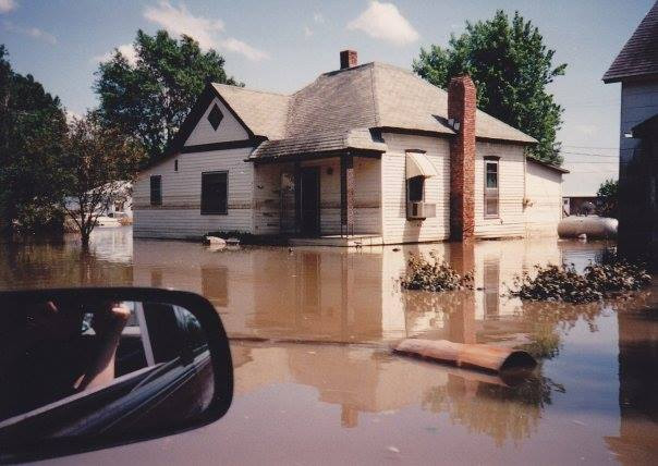
Grand River water flooding at Pattonsburg, MO, in 1993.

Grand River water flooding at Pattonsburg, MO, in 1993.
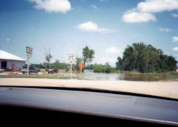
Grand River water flooding the highway junction of Route Z and US-69 at the east entrance into Pattonsburg, MO, in 1993.

Trash accumulated on the schoolyard until removal could be arranged.

School supplies in good condition were taken to the gymnasium to be sorted and reused.

Room by room the flood damage was extensive in Pattonsburg R-2 School after the flood of 1993.